protect the city from a feared Confederate attack. Though the forts have long since vanished
beneath modern neighborhoods, their story remains written across the ridges, roads, and river
bends of the city. This tour follows the original defensive line from west to east, highlighting
modern landmarks, what to look for today, and the historical significance of each site.
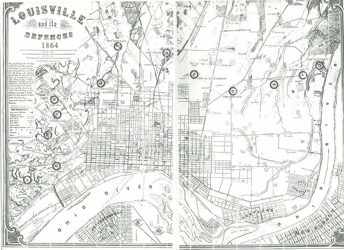
Stop 1 — Fort Southworth (Paddy’s Run)
Modern Location: Near Paddy’s Run Pump Station, west of N 36th St
Best Access: Drive
What to Look For: Subtle rise above the floodplain; bend in the Ohio River
Fort Southworth anchored the western end of Louisville’s defenses. Its artillery could sweep
the river bend and support Fort Clark to the east, forming the first link in the defensive chain.
Stop 2 — Fort Clark (36th & Magnolia)
Modern Location: 36th St & Magnolia Ave
Best Access: Easy street parking
What to Look For: Gentle ridge running east–west; long sightline toward downtown
Fort Clark guarded one of the main southern roads into Louisville and provided overlapping
fields of fire with both Fort Southworth and Fort Karnash.
Stop 3 — Fort Karnash (Wilson Ave, 26th–28th Streets)
Modern Location: Wilson Ave between 26th & 28th
Best Access: Drive or short walk
What to Look For: Slight elevation above surrounding blocks
Fort Karnash filled the gap between Fort Clark and Fort St. Clair Morton, forming the
mid‑western arc of the defensive line.
Stop 4 — Fort St. Clair Morton (16th & Hill Streets)
Modern Location: 16th St & Hill St
Best Access: Drive
What to Look For: High ground overlooking Dixie Highway
One of the most strategically placed forts, St. Clair Morton commanded the old Salt River
Turnpike — today’s Dixie Highway — a major approach into the city.
Stop 5 — Fort Philpot (Algonquin Pkwy & 7th Street Road)
Modern Location: Near Algonquin Pkwy & 7th Street
Best Access: Drive
What to Look For: Rise controlling the 7th Street corridor
Fort Philpot protected the southwestern approaches and supported the defenses along the
L&N Turnpike.
Stop 6 — Fort McPherson (Preston Hwy Corridor)
Modern Location: Near Preston Hwy & Eastern Pkwy
Best Access: Drive
What to Look For: Broad elevated ground; long southern sightlines
The largest and most heavily armed fort in Louisville, McPherson mounted a 100‑pounder
Parrott rifle with a five‑mile range — the most powerful gun in the city’s defenses.
Stop 7 — Fort Horton (Merriwether & Shelby Streets)
Modern Location: Merriwether Ave & Shelby St
Best Access: Walkable neighborhood
What to Look For: Slight rise along the Shelby Street corridor
Fort Horton guarded the southeastern roads into Louisville and linked the central and eastern
sectors of the defensive line.
Stop 8 — Fort Hill (Castlewood Ave / St. Louis Cemetery Ridge)
Modern Location: Ridge between St. Louis Cemetery & Castlewood Ave
Best Access: Park near Barret Middle School
What to Look For: Prominent ridge overlooking the Highlands
Fort Hill commanded the high ground between the central and eastern portions of the line,
providing long views toward the Highlands.
Stop 9 — Fort Engle (Arlington Ave & Spring Street)
Modern Location: Arlington Ave & Spring St
Best Access: Walkable; steep terrain
What to Look For: Dramatic drop toward Beargrass Creek; rail corridor below
Fort Engle worked with Fort Elstner to protect the northeastern approaches and the canal
system along Beargrass Creek.
Stop 10 — Fort Elstner (Bellaire, Emerald & Vernon Avenues)
Modern Location: Clifton hillside above Beargrass Creek
Best Access: Walkable neighborhood
What to Look For: High spur overlooking the creek bend
Manned by USCT regiments, Fort Elstner anchored the Beargrass Creek line and protected the
canal and northeastern approaches.
Stop 11 — Fort Saunders (Cave Hill Cemetery)
Modern Location: Inside Cave Hill Cemetery, on the eastern ridge
Best Access: Walk or drive inside cemetery
What to Look For: High ground east of the lake; views toward the Highlands
Fort Saunders completed the defensive arc, guarding the eastern approaches to Louisville and
tying the entire line together.