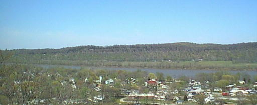
Historic View
From this lookout, the soldiers who garrisoned Fort Duffield could observe all military
activity taking place in the town of West Point below. Early in the war, West Point,
Kentucky served as the main supply base for General William Tecumseh Sherman’s army,
positioned forty miles south along the Louisville–Nashville Turnpike.
What Happened Here
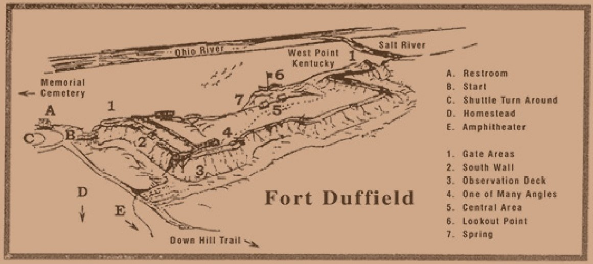
1. A Natural Military Vantage Point
Perched atop the steep escarpment of Muldraugh Hill, this overlook gave Union forces a
commanding view over the Salt River and Ohio River valleys. In late 1861, General William
Tecumseh Sherman ordered the construction of Fort Duffield just below this ridge to protect
the vital Union supply lines feeding the Western Theater.
2. Watching the Lifeline of the Union Army
From this elevation, Union troops monitored troop movements, guarded steamboat landings,
and secured wagon routes delivering supplies from Louisville to southern training camps.
The 9th Michigan Infantry, under Colonel William W. Duffield, built the fort and bridges
that made West Point a logistical lifeline for the Union Army.
3. Quiet Work That Shaped the War
Though never attacked directly, Fort Duffield and the lookout above it played a quiet but
crucial role in preserving Union control of Kentucky — an essential goal of President
Abraham Lincoln, who famously said, “I hope to have God on my side, but I must have
Kentucky.”
Lovers Leap and the Landscape
The overlook point on Muldraugh Hill is known locally as Lovers Leap. When the fort
was being built, all the trees were cleared for at least a mile around. Soldiers harvested
the timber for lumber and for fueling the steamboats that supplied the Union Army.
What Makes the Lookout Special
- Panoramic Views: Sweeping views of the Salt River valley, Fort Knox woodlands, and the Ohio River basin.
- Historical Significance: A key observation point protecting the Louisville & Nashville Railroad and Union supply lines.
- Scenic Drive: The ascent up Muldraugh Hill is especially beautiful in autumn and spring.
The terrain itself — steep, forested, and commanding — became part of the fort’s defensive
strength. The view you see today is a direct link to the soldiers who once stood watch on
this ridge.
Listen or Explore More
Audio Narration
Hear how the overlook shaped the fort’s defensive strategy and the daily experience of watch duty.
Primary Sources & Research
Documents Related to the Overlook
These primary sources help reconstruct what Union soldiers actually saw from the ridge in 1861—terrain,
sightlines, engineering decisions, and firsthand accounts of watch duty at Fort Duffield.
-
Station Six Overlook Packet (PDF)
Terrain sketches, elevation notes, and reconstructed sightlines showing how the ridge
dominated the Salt River and Turnpike approaches. -
Louisville Defenses Map (1864)
Period map placing Fort Duffield within the broader defensive network protecting Louisville
and the river corridors. -
Fort Duffield Construction Notes (1861–62)
Engineering records describing why the ridge was chosen, how the slopes were cleared,
and how observation posts were positioned. -
Letters from the 9th Michigan Infantry
Firsthand descriptions of picket duty, the steep climb to the fort, and the sweeping
views soldiers relied on for early warning. -
Union Soldier Diary — Kentucky Campaign
Daily notes on terrain, visibility, and the strategic importance of the overlook during
the winter of 1861–62.
Navigation
Walking Tour Quick Links
© 2026 Fort Duffield • Built with GeneratePress