Station 2 — The South Wall
Historic View
Looking westward
What Happened Here
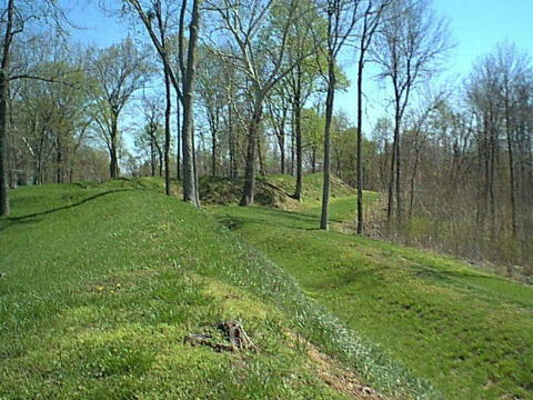
The South Wall formed one of Fort Duffield’s strongest defensive lines. Soldiers shaped this ridge in late 1861 by cutting logs, piling earth, and clearing trees to create a protected firing position overlooking the valleys below. From here, Union guards watched for movement—smoke, glints of metal, or the sound of horses—while remaining hidden behind the crest of the hill.
Although the South Wall was designed for defense, it also contained a practical feature essential to daily operations: a sally port. A sally port was a narrow, hidden passage built into the earthworks, allowing soldiers to leave the fort without being seen from the valley. At Fort Duffield, this passage was located on the southwest end of the South Wall, where the ridge begins to curve and the slope becomes more walkable.
Standing at the midpoint of the South Wall, the sally port would have been west of your position, near the point where the ridge drops toward the southwest. This location offered concealment, drainage, and a safe descent route toward the supply road and camp area below. The opening itself has eroded, but the break in the earthwork line and the gentle dip in the slope still mark where the passage once existed.
The South Wall remains one of the clearest examples of how Union engineers used the natural terrain to strengthen the fort. Even after more than 160 years, the contours of the ridge still reveal the defensive logic behind its construction—and the hidden routes soldiers used to move in and out of the fort.
Understanding the Terrain
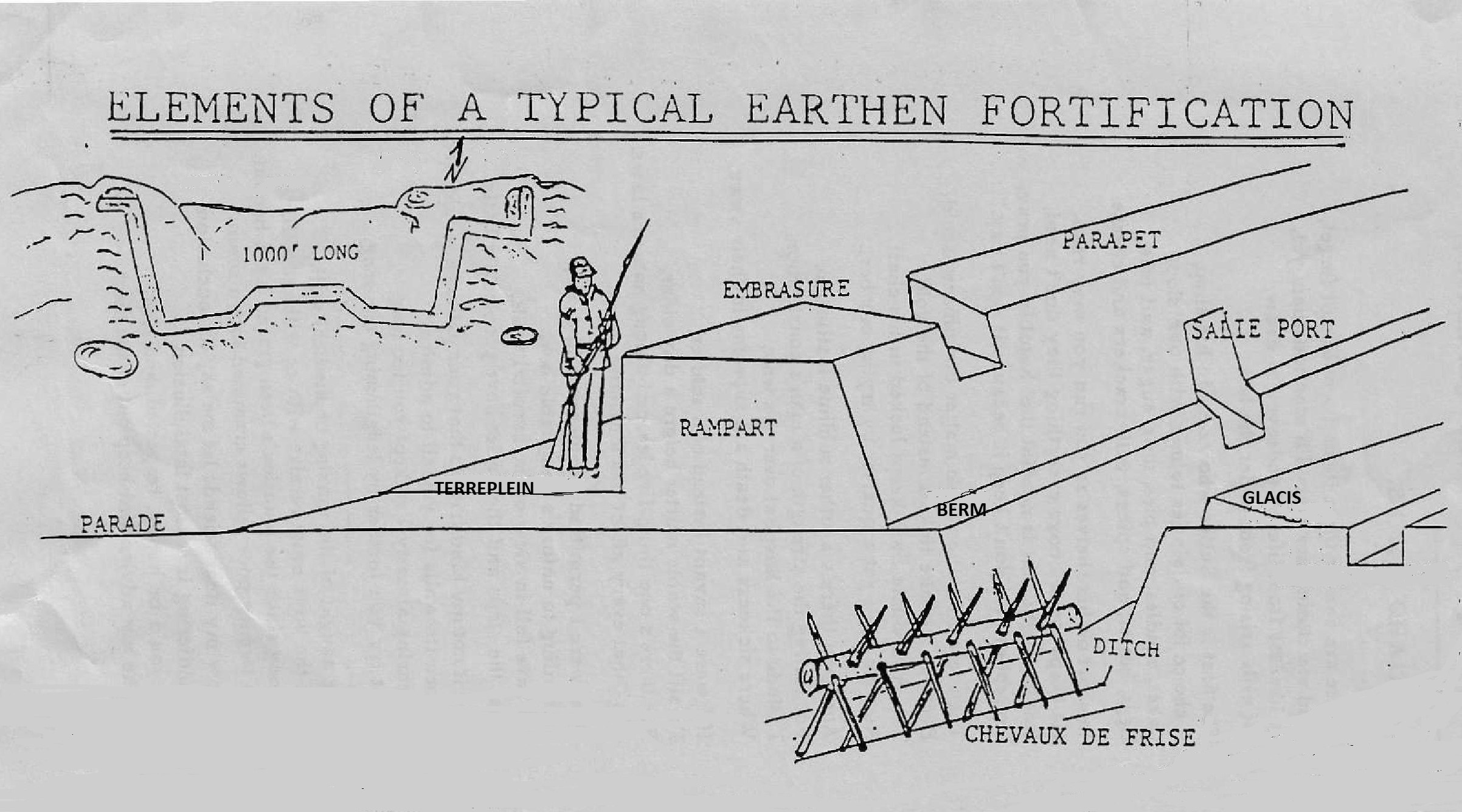
The map and photos on this page use several terms that describe the structure of the South Wall and the surrounding landscape:
- Parapet: The raised earth ridge forming the top of the South Wall. Soldiers stood behind it for protection.
- Rampart: The entire defensive earthwork—parapet plus supporting embankment—that formed the main line of protection around the fort.
- Berm: The sloped interior side of the wall. Steps or worn paths on the berm show where soldiers climbed up to the firing line.
- Terreplein: The level or gently sloping surface behind the parapet where soldiers stood, moved, and positioned artillery or small arms.
- Ditch: A shallow depression running along the inside of the wall. It helped with drainage and provided a walkway behind the parapet.
- Sally Port: A hidden exit cut through the wall. At Fort Duffield, it was located on the southwest end of the South Wall, where the ridge bends and the slope becomes easier to descend.
- Chevaux de frise: Defensive obstacles made of timbers with projecting stakes or spikes, placed in front of the rampart or along approaches to slow or break an attacking force.
- Southwest Slope: The downhill area outside the wall. This slope concealed soldiers as they moved between the fort and the supply road.
Interpretive Signage at the Sidewalk
As you approached this station, you passed interpretive information about Fort Duffield and the officers who served here, including General William Tecumseh Sherman, whose headquarters was located in West Point during the early months of the Civil War. The signage also includes a period photograph of Abraham Lincoln, reflecting the national leadership that shaped the Union war effort.
Sherman’s Headquarters in West Point, Kentucky
Sherman’s headquarters—not to be confused with the U.S. Military Academy at West Point, New York—was located in the historic Judge Fisher House, built in 1845. This residence served as Sherman’s command post in 1861 while he oversaw Union operations in the region.
- Location: Elm Street & North 4th Street, West Point, Kentucky
- Historical Significance: Used by Sherman while commanding Union troops in the area
- Structure: Private residence built in 1845, now marked by a historical plaque
- Marker Notes: Highlights Sherman’s use of the home as his headquarters during the Civil War
This site is part of a cluster of Civil War landmarks in West Point, including the Ditto‑Lansdale House (used as a hospital) and the Salt Warehouse, which supported Union logistics.
Listen or Explore More
Audio Narration
Hear how the South Wall protected the fort and shaped daily guard duty.
Primary Sources & Research
Primary Sources Coming Soon
Archival documents, maps, and engineering notes for this stop are being prepared and will be added soon.
Navigation
Walking Tour Quick Links
© 2026 Fort Duffield • Built with GeneratePress